

Canadians seeking sunshine and warmth are likely to welcome a summer forecast promising plenty of both, according to Weather Network meteorologist Doug Gillham. However, he warns that this season could demonstrate the drawbacks of excessive heat, highlighting potential difficulties such as droughts, wildfires, and severe thunderstorms across various parts of Canada during the summer months of June, July, and August.
"I believe most people will be pleasantly surprised by the forecast at first," said Gillham, the manager of The Weather Network's forecast centre. He noted that while the initial outlook may seem positive, it also comes with precautions due to the extreme heat and insufficient rainfall expected in some regions, alongside stormy weather in others.
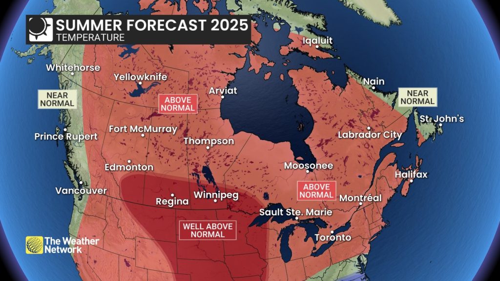
A warm and humid summer is predicted for much of Ontario and Quebec, extending into the Maritimes. Gillham explained that muggy conditions are likely to foster powerful thunderstorms and maintain elevated nighttime temperatures throughout Central Canada. Heat waves may occur earlier in the season, possibly even before July, although prolonged heat is not expected—except for areas west of Lake Superior.
As the forecast shifts towards the Ontario-Manitoba boundary, conditions are anticipated to become warmer and drier than normal, especially as recent wildfires have already illustrated the risks involved this summer. Several communities in the region have experienced evacuations due to rapidly spreading fires. Gillham emphasized the need for heightened vigilance this summer to prevent wildfires since the conditions are more favorable for the spread of fires if they begin.
The criteria for what is considered "normal" weather has evolved due to global warming, mainly attributed to heat-trapping fossil fuel emissions. The forecasts predicting above- or below-normal temperatures and precipitation are grounded in average conditions observed over the last 30 years. However, records indicate that average summer temperatures in Canada have increased by nearly two degrees since the late 1940s, leading to more severe wildfires, droughts, and heat waves. "It shifts the goalposts and the range of possibility," Gillham noted.
Furthermore, drought is expected to pose a significant challenge in the southern Prairie regions, where well above-normal temperatures are likely to coincide with below-normal precipitation levels. Gillham mentioned that conditions leading into this summer are more favorable than in previous drought years, such as 2012. The forecast suggests warmer-than-normal temperatures for the northern areas of Alberta, Saskatchewan, and Manitoba, but with near-normal precipitation levels.
The overarching forecast shares similarities with the summer of 2021, which was characterized by drought, wildfires, water shortages, and a devastating heat wave that impacted British Columbia. Gillham hesitated to draw parallels, acknowledging that residents in BC are likely unwilling to revisit memories of that year. However, he indicated that the emphasis this season might shift slightly further east, particularly concerning the southern Prairies.
The British Columbia coast is expected to experience near-normal temperatures and precipitation, aside from a wetter-than-normal forecast near the Yukon boundary. In the central and southern interior, conditions are predicted to be warmer and drier than normal. In the northern regions, above-normal temperatures and near-normal precipitation are projected across most territories, with Gillham keeping a close eye on potential wildfire activity. Exceptions are seen in western Yukon, expected to have near-normal temperatures mixed with above-normal precipitation, and northern Baffin Island, which could experience near-normal temperatures.
As we approach hurricane season, the forecast indicates a typical yet active pattern, continuing the trend of above-average hurricane activity since 2016. The jet stream's behavior this year appears to support a storm track that may direct hurricanes toward either the northeastern United States or Atlantic Canada, with some remnants potentially affecting parts of Ontario and Quebec. Gillham cautioned that while there could be fewer storms overall, just one impactful storm can have significant consequences.
Climate change has also contributed to increased ocean temperatures in the Atlantic, which may be exacerbating the intensity of hurricanes. Last year, there were 18 named storms, including the earliest recorded Category 5 hurricane, Beryl. This year, Environment and Climate Change Canada has projected 13 to 19 named storms, with estimates of six to 10 hurricanes and three to five major hurricanes in the Atlantic Ocean basin. The hurricane season spans from June through the end of November.
The Weather Network's summer forecast indicates that most of the Maritimes and western Newfoundland can expect above-normal temperatures and precipitation, occasionally interrupted by cold fronts. Near-normal precipitation is expected for Newfoundland and Labrador, as well as eastern Nova Scotia.


