

The Weather Network's seasonal forecast indicates that Canada is experiencing a dramatic start to fall weather, characterized by record-breaking heat in British Columbia and early cold snaps in Central and Eastern Canada. Doug Gillham, a senior meteorologist at the Weather Network, noted that this month has showcased a significant contrast in temperatures.
However, from mid-September through October, most regions of Canada are predicted to "hit the pause button" on these temperature extremes. The forecast suggests a dominance of warmer-than-normal temperatures, with fewer storms affecting the area during the heart of the season. Gillham explained that, although there will be temperature fluctuations, the milder periods will outweigh the cooler spells, allowing Canadians to enjoy outdoor activities and fall foliage.
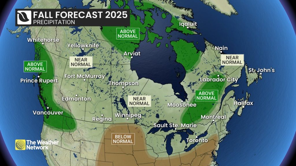
A transition to more active and changeable conditions is expected in November, with the forecast indicating that storm activity will increase and precipitation levels will return to near normal for most of the country. Some regions, particularly Northern Canada, the B.C. coast, and parts of northeastern Ontario through to central Quebec and Labrador, may experience slightly wetter conditions than usual. Gillham described this seasonal pattern as having a "wild start," followed by a quieter mild phase, before leading to more typical late-fall weather.
The forecast of near-normal precipitation comes as a relief for the northern Prairies, where drought conditions have prevailed throughout the summer. Nonetheless, there remains uncertainty regarding the precipitation forecast for Atlantic Canada, which has been unusually dry. Gillham highlighted the potential impact of tropic weather patterns, stating that the second half of the hurricane season might bring increased activity, primarily targeting Florida. Cooler North Atlantic waters may help weaken storms as they approach the Canadian coast, although Gillham cautioned that just one significant system could still pose risks to Atlantic Canada.
For Ontario and Quebec, the forecast indicates an initial chilly start to September, followed by warmer-than-normal temperatures before November's storm activity increases. A similar pattern is anticipated in the Prairies, where temporary cold spells may interrupt otherwise pleasant fall weather. By November, a shift to a colder and more active weather pattern will likely signal the onset of winter in the region.
In Western Canada, wildfire smoke is expected to remain a concern for several more weeks until the rainy season takes hold. Temperatures are forecasted to drop over the next few weeks, but remain warmer than average through the end of September and into early October. Meanwhile, the recent heat in British Columbia will give way to near-normal temperatures, coupled with a typical number of fall storms. However, the coast could experience above-normal precipitation due to warmer temperatures in the northern Pacific Ocean.
Gillham indicated that although the storms forecasted for British Columbia may not be more frequent, they could carry a higher risk of excessive rain. The warm waters in the northern Pacific are influencing the jet stream's position, which is expected to contribute to a quieter and warmer middle of the fall season. Nevertheless, the jet stream's gradual shift southward indicates that the storm track will also follow suit, leading to potential cold air outbreaks in November.
The forecast predicts near normal precipitation across much of Yukon and the Northwest Territories, with above-normal levels expected in Nunavut. Overall, the majority of Northern Canada is forecasted to experience above-normal temperatures this season.
It is critical to note that climate change, primarily fueled by fossil fuel combustion, has altered meteorologists' understanding of what is considered normal across Canada. The projections for temperatures and precipitation are based on averages from the last 30 years. Federal data indicates that autumn average temperatures have risen by 2.4 degrees since 1948 across Canada.
This report encapsulates essential insights into the weather changes anticipated across Canada for the upcoming season, highlighting the interplay between local meteorological patterns and broader climatic shifts.


